KKeine Bearbeitungszusammenfassung |
|||
| (20 dazwischenliegende Versionen von 2 Benutzern werden nicht angezeigt) | |||
| Zeile 1: | Zeile 1: | ||
| + | {{übersetzen}} |
||
{{stub}} |
{{stub}} |
||
{{Infoboxorte3 |
{{Infoboxorte3 |
||
| − | | name = Pontar |
+ | | name = Pontar Region |
| bild = Tw3 map pontar region.jpg |
| bild = Tw3 map pontar region.jpg |
||
| − | | beschreibung = In-game map of the Pontar |
+ | | beschreibung = In-game map of the Pontar Region in The Witcher 3 |
| − | | art = [[:Kategorie: |
+ | | art = [[:Kategorie:Regionen|Region]] |
| − | | lage = [[Pontar Delta]]; large mass where the battlefronts between the [[ |
+ | | lage = [[Pontar Delta]]; large mass where the battlefronts between the [[Nilfgaard]] and [[Nördliche Königreiche]] lie |
}} |
}} |
||
| − | In ''[[The Witcher 3: Wild Hunt]]'', the '''Pontar''' represents part of the world map that covers the [[Pontar Delta]] region. It consists of war-torn [[Velen]], the independent city of [[Novigrad]] and southern parts of [[ |
+ | In ''[[The Witcher 3: Wild Hunt]]'', the '''Pontar''' represents part of the world map that covers the [[Pontar Delta]] region. It consists of war-torn [[Velen]], the independent city of [[Novigrad]] and southern parts of [[Redanien]] territory, including the city of [[Oxenfurt]]. Although the in-game map labels the two major regions as "Velen & Novigrad", both are contained on the same game world. |
| − | The game's rendition of the region excludes some locations from the [[Witcher |
+ | The game's rendition of the region excludes some locations from the [[The Witcher Serien und Adaptationen|Witcher saga]], namely [[Eibenbucht]], [[Kranichwerder]], the city of [[Gyscht]], and the settlement of [[Weißbrücke]] (originally intended to appear). |
The region holds (with the ''[[Hearts of Stone]]'' expansion included): |
The region holds (with the ''[[Hearts of Stone]]'' expansion included): |
||
| + | {| style="width: 75%;" |
||
| − | {{cols|3| |
||
| + | |-valign="top" |
||
| − | * TBA villages |
||
| + | | width=33%" | |
||
| − | * 111 {{schnellreisen}} [[fast travel|signposts]] |
||
| + | {| |
||
| − | * 8 {{Ort der Macht}} [[Place of Power#White Orchard|places of power]] |
||
| + | |-valign="top" |
||
| − | * 16 {{Verlassene Stätte}} [[abandoned site]]s |
||
| + | | || align="right" | TBA || Dörfer |
||
| − | * 32 {{bandit camp}} [[bandit camp]]s |
||
| + | |- |
||
| − | * 32 {{guarded treasure}} [[guarded treasure]]s |
||
| + | | {{schnellreisen}} || align="right" | 111 || [[Schnellreisen|Wegweiser]] |
||
| − | * 29 {{Versteckter Schatz}} [[hidden treasure]]s |
||
| + | |- |
||
| − | * 4 {{Monsterlager}} [[monster den]]s |
||
| + | | {{Ort der Macht}} || align="right" | 8 || [[Ort der Macht#White Orchard|Ort der Macht]] |
||
| − | * 29 {{Monsternest}} [[monster nest]]s |
||
| + | |- |
||
| − | * 27 {{dungeon}} [[Cave#In The Witcher 3: Wild Hunt|cave entrances]] |
||
| + | | {{Verlassene Stätte}} || align="right" | 16 || [[Verlassene Stätte]] |
||
| − | * 11 {{Hafen}} [[harbor]]s |
||
| + | |- |
||
| − | * 19 {{grindstone}} [[grindstone]]s |
||
| + | | {{Banditenlager}} || align="right" | 32 || [[Banditenlager]]s |
||
| − | * 11 {{workbench}} [[armorer's table]]s |
||
| ⚫ | |||
| − | * 4 {{smuggler}} [[smugglers' cache]] |
||
| + | || |
||
| − | * 3 {{spoil}} [[spoils of war]] |
||
| + | {| |
||
| − | * 6 {{Käfig}} [[person(s) in distress]] |
||
| + | |-valign="top" |
||
| − | * 19 {{notice board}} [[Notice board#White Orchard|notice board]]s |
||
| + | | {{Bewachter Schatz}} || align="right" | 32 || [[Bewachter Schatz]] |
||
| ⚫ | |||
| + | |- |
||
| + | | {{Versteckter Schatz}} || align="right" | 29 || [[Versteckter Schatz]] |
||
| + | |- |
||
| + | | {{Monsterlager}} || align="right" | 4 || [[Monsterlager]] |
||
| + | |- |
||
| + | | {{Monsternest}} || align="right" | 29 || [[Monsternest]] |
||
| + | |- |
||
| + | | {{Höhleneingang}} || align="right" | 27 || [[Höhlen#In The Witcher 3: Wild Hunt|Höhleneingang]] |
||
| + | |- |
||
| + | | {{Hafen}} || align="right" | 11 || [[Hafen]] |
||
| + | |} |
||
| + | | width=33%" | |
||
| + | {| |
||
| + | |-valign="top" |
||
| + | | {{wetzstein}} || align="right" | 19 || [[Wetzstein]]e |
||
| + | |- |
||
| + | | {{Werkbank}} || align="right" | 11 || [[Tisch des Rüstungsschmieds]] |
||
| + | |- |
||
| + | | {{Schmugglerversteck}} || align="right" | 4 || [[Schmugglerversteck]]en |
||
| + | |- |
||
| + | | {{Kriegsbeute}} || align="right" | 3 || [[Kriegsbeute]] |
||
| + | |- |
||
| + | | {{Käfig}} || align="right" | 6 || [[Person(en) in Not]] |
||
| + | |- |
||
| + | | {{Anschlagbrett}} || align="right" | 19 || [[Anschlagtafeln#Weißgarten|Anschlagbretter]] |
||
| + | |} |
||
| + | |} |
||
| − | The region is also a home for 9 {{ |
+ | The region is also a home for 9 {{tavernenwirt}} [[Tavernenwirt]], 7 {{waffenschmied}} [[Waffenschmied]]e, 6 {{rüstungsschmied}} [[Rüstungsschmied]]e, 12 {{kräuterhändler}} [[Kräuterhändler]] and 69 {{Händler}} [[Händler (The Witcher 3)|Händler]]. |
== [[Velen]] == |
== [[Velen]] == |
||
| − | The former [[ |
+ | The former [[Temerien]] province of Velen (also known as No Man's Land) - currently under [[Nilfgaard]]ian occupation - also constitutes the largest part of the Pontar region. Situated south of Novigrad and west of Oxenfurt, its provisional capital is [[Krähenfels]]. The prevailing terrain consists of forests and swamps. |
| − | === |
+ | === Orte === |
{{cols|3| |
{{cols|3| |
||
| − | * [[ |
+ | * [[Der Kahle Berg (Ort)|Der Kahle Berg]] |
| − | * [[ |
+ | * [[Buckelsumpf]] |
| − | * [[ |
+ | * [[Der Abstieg]] |
| − | * [[ |
+ | * [[Reuseninsel]] |
| − | * [[ |
+ | * [[Graufels]] |
| − | * [[ |
+ | * [[Der Morast]] |
| − | * [[ |
+ | * [[Schlammacker]] |
| − | * [[ |
+ | * [[Feuerklippen]] |
}} |
}} |
||
=== Keeps and villages === |
=== Keeps and villages === |
||
{{cols|3| |
{{cols|3| |
||
| − | * [[ |
+ | * [[Benkelheim]] |
| − | * [[ |
+ | * [[Schwarzzweig]] |
| − | * [[ |
+ | * [[Kleinweg]] |
| − | * [[ |
+ | * [[Sandort]] |
| − | * [[ |
+ | * [[Kondylus]] |
| − | * [[ |
+ | * [[Krähenfels]] |
| − | * [[ |
+ | * [[Niederwirr]] |
* [[Frischlow]] |
* [[Frischlow]] |
||
| − | * [[ |
+ | * [[Heidfelde]] |
| − | * [[ |
+ | * [[Lindental]] |
* [[Lurtch]] |
* [[Lurtch]] |
||
| − | * [[ |
+ | * [[Mittelhain]] |
| − | * [[ |
+ | * [[Erzdorf]] |
* [[Toderas]] |
* [[Toderas]] |
||
}} |
}} |
||
| − | === |
+ | === Graufels und Schlammacker === |
{{cols|3| |
{{cols|3| |
||
| − | * [[ |
+ | * [[Steinbruch der Alten]] |
| − | * [[ |
+ | * [[Teufelsgrube]] |
| − | * [[ |
+ | * [[Fährhaus]] |
| − | * [[ |
+ | * [[Galgenhügel]] |
| − | * [[ |
+ | * [[Hindwacht]] |
| − | * [[ |
+ | * [[Taverne am Scheideweg]] (Schlammacker) |
| − | * [[ |
+ | * [[Maulbeertal]] |
| + | * [[Siedlung der Steinschneider]] |
||
| − | * [[Stonecutters' Settlement]] |
||
| − | * [[ |
+ | * [[Fort Weißer Adler]] |
}} |
}} |
||
=== Other locations === |
=== Other locations === |
||
{{cols|3| |
{{cols|3| |
||
| − | * [[ |
+ | * [[Verlassener Turm]] |
| − | * [[ |
+ | * [[Alte Eiche]] |
| − | * [[ |
+ | * [[Teufelsgrube]] |
| − | * [[ |
+ | * [[Reuseninsel]] |
| − | * [[ |
+ | * [[Haus der Erholung]] |
| − | * [[Kimbolt |
+ | * [[Kimbolt-Straße]] |
* [[Lornruk]] |
* [[Lornruk]] |
||
| + | * [[Lager der Zentralarmee von Nilfgaard]] |
||
| − | * [[Nilfgaardian Army Group 'Center' Camp]] |
||
| − | * [[ |
+ | * [[Olenas Hain]] |
| − | * [[ |
+ | * [[Straßen zum Kahlen Berg]] |
| + | * [[Waisendorf im Buckelsumpf]] |
||
| − | * [[The Orphans of Crookback Bog]] |
||
| − | * [[Wastrel |
+ | * [[Wastrel-Anwesen]] |
}} |
}} |
||
== [[Novigrad]] == |
== [[Novigrad]] == |
||
| − | === |
+ | === Stadtteile === |
{{cols|3| |
{{cols|3| |
||
| − | * [[ |
+ | * [[Die Scherben]] |
| − | * [[ |
+ | * [[Ferneck]] |
| − | * [[ |
+ | * [[Fischmarkt]] |
* [[Gildorf]] |
* [[Gildorf]] |
||
| − | * [[ |
+ | * [[Hafenviertel]] |
| − | * [[ |
+ | * [[Spitzenhall]] |
| − | * [[ |
+ | * [[Stinkende Hecke]] |
| − | * [[ |
+ | * [[Silberstein]] |
| − | * [[ |
+ | * [[Tempelinsel]] |
}} |
}} |
||
| − | === |
+ | === Schnellreisepunkte === |
{{cols|3| |
{{cols|3| |
||
| − | * [[ |
+ | * [[Kurfürstenplatz]] |
| − | * [[ |
+ | * [[Tor des Hierarchen]] |
| − | * [[ |
+ | * [[Platz des Hierarchen]] |
| − | * [[ |
+ | * [[Ruhmestor]] |
| − | * [[ |
+ | * [[Novigrader Docks]] |
| − | * [[ |
+ | * [[Oxenfurter Tor]] |
| − | * [[ |
+ | * [[Hafentor]] |
| − | * [[ |
+ | * [[Südtor]] |
| − | * [[St. |
+ | * [[St. Georgs Brücke]] |
| − | * [[ |
+ | * [[Dreibergtor]] |
}} |
}} |
||
| − | === |
+ | === Interessante Orte === |
{{cols|3| |
{{cols|3| |
||
| − | * [[ |
+ | * [[Krüppelkati]] |
| − | * [[ |
+ | * [[Zum Goldenen Stör]] |
| − | * [[ |
+ | * [[Der Eisvogel]] |
* [[Passiflora]] |
* [[Passiflora]] |
||
| − | * [[ |
+ | * [[Das Nirgendwo]] |
| − | * [[ |
+ | * [[Rosmarin und Thymian]] / [[Chamäleon]] |
}} |
}} |
||
| Zeile 138: | Zeile 166: | ||
* [[Alness]] |
* [[Alness]] |
||
* [[Arette]] |
* [[Arette]] |
||
| − | * [[ |
+ | * [[Caerstuen]] |
| − | * [[ |
+ | * [[Tanzende Windmühle]] |
| − | * [[ |
+ | * [[Imkerei Honigwab]] |
| − | * [[ |
+ | * [[Die Sieben Katzen]] |
| + | * [[Anwesen der Vegelbuds]] |
||
| − | * [[Vegelbud Residence|Vegelbud Estate]] |
||
| − | * [[ |
+ | * [[Weizenfelder]] |
}} |
}} |
||
| − | === |
+ | === Grashügel (southern outskirts) === |
{{cols|3| |
{{cols|3| |
||
| − | * [[ |
+ | * [[Die Gänsemöse]] |
| − | * [[ |
+ | * [[Burg Drahim]] |
| − | * [[ |
+ | * [[Kapelle des Ewigen Feuers]] |
| − | * [[ |
+ | * [[Leuchtturm]] |
| − | * [[ |
+ | * [[Holzfällerhütte]] |
| − | * [[ |
+ | * [[Lucians Windmühle]] |
* [[Ursten]] |
* [[Ursten]] |
||
| − | * [[ |
+ | * [[Witwengrotte]] |
}} |
}} |
||
| − | == [[ |
+ | == [[Sturmfelder]] == |
East of both Velen and Novigrad's outskirts lie lands and settlements under the jurisdiction of the Kingdom of Redania. |
East of both Velen and Novigrad's outskirts lie lands and settlements under the jurisdiction of the Kingdom of Redania. |
||
=== [[Oxenfurt]] === |
=== [[Oxenfurt]] === |
||
{{cols|3| |
{{cols|3| |
||
| − | * [[ |
+ | * [[Hafen von Oxenfurt]] |
| − | * [[ |
+ | * [[Novigrader Tor]] |
| − | * [[ |
+ | * [[Westtor]] |
}} |
}} |
||
| − | === |
+ | === Anwesen === |
{{cols|3| |
{{cols|3| |
||
| − | * [[Garin |
+ | * [[Garin-Anwesen]] |
| − | * [[Moldavie |
+ | * [[Moldavie-Anwesen]] |
| − | * [[Von |
+ | * [[Von-Everec-Anwesen]] |
}} |
}} |
||
=== Settlements and villages === |
=== Settlements and villages === |
||
{{cols|3| |
{{cols|3| |
||
| − | * [[ |
+ | * [[Bogendorf]] |
* [[Brunwich]] |
* [[Brunwich]] |
||
* [[Erde]] |
* [[Erde]] |
||
| − | * [[ |
+ | * [[Sturmfelder Hof]] |
* [[Heddel]] |
* [[Heddel]] |
||
| + | * Alte Mühle |
||
| − | * Lower Mill |
||
| − | * [[Martin |
+ | * [[Martin Feuilles Hof]] |
| − | * [[ |
+ | * [[Dorf Mohrin|Mohrin]] |
| − | * [[ |
+ | * [[Château Sarrasin]] |
| − | * [[ |
+ | * [[Neue Mühle]] |
| − | * [[ |
+ | * [[Château Fraîche]] |
* [[Yantra]] |
* [[Yantra]] |
||
}} |
}} |
||
| Zeile 193: | Zeile 221: | ||
=== Other locations === |
=== Other locations === |
||
{{cols|3| |
{{cols|3| |
||
| − | * [[Aeramas' |
+ | * [[Aeramas' verlassenes Anwesen]] |
| − | * [[ |
+ | * [[Ruine von Burg Arnskrone]] |
| − | * [[ |
+ | * [[Höhle (Sturmfelder)|Höhle]] |
| − | * [[ |
+ | * [[Kranichskap]] |
| − | * [[ |
+ | * [[Wegkreuzung (Oxenfurt)|Wegkreuzung]] |
| − | * [[ |
+ | * [[Außenposten von Drachenmulde]] |
* [[Est Tayiar]] |
* [[Est Tayiar]] |
||
| + | * [[Hütte des Kräuterkundlers]] |
||
| − | * [[Herbalist's Hut]] |
||
| − | * [[ |
+ | * [[Jägerhütte]] |
| + | * [[Einsame Hütte]] |
||
| − | * [[Isolated Hut (Gustfields)|Isolated Hut]] |
||
| − | * [[Kilkerinn |
+ | * [[Kilkerinn-Ruine]] |
| − | * [[ |
+ | * [[Müllersee]] |
| + | * [[Versteck temerischer Freischärler]] |
||
| − | * [[Temerian Partisan Hideout]] |
||
| − | * [[ |
+ | * [[Wachturm von Vikk]] |
| − | * [[ |
+ | * [[Burg Zuetzer]] |
}} |
}} |
||
| Zeile 214: | Zeile 242: | ||
{{tw3region}} |
{{tw3region}} |
||
| + | |||
| + | [[en:Pontar (region)]] |
||
Version vom 23. Mai 2017, 19:38 Uhr
| Pontar Region | |
|---|---|
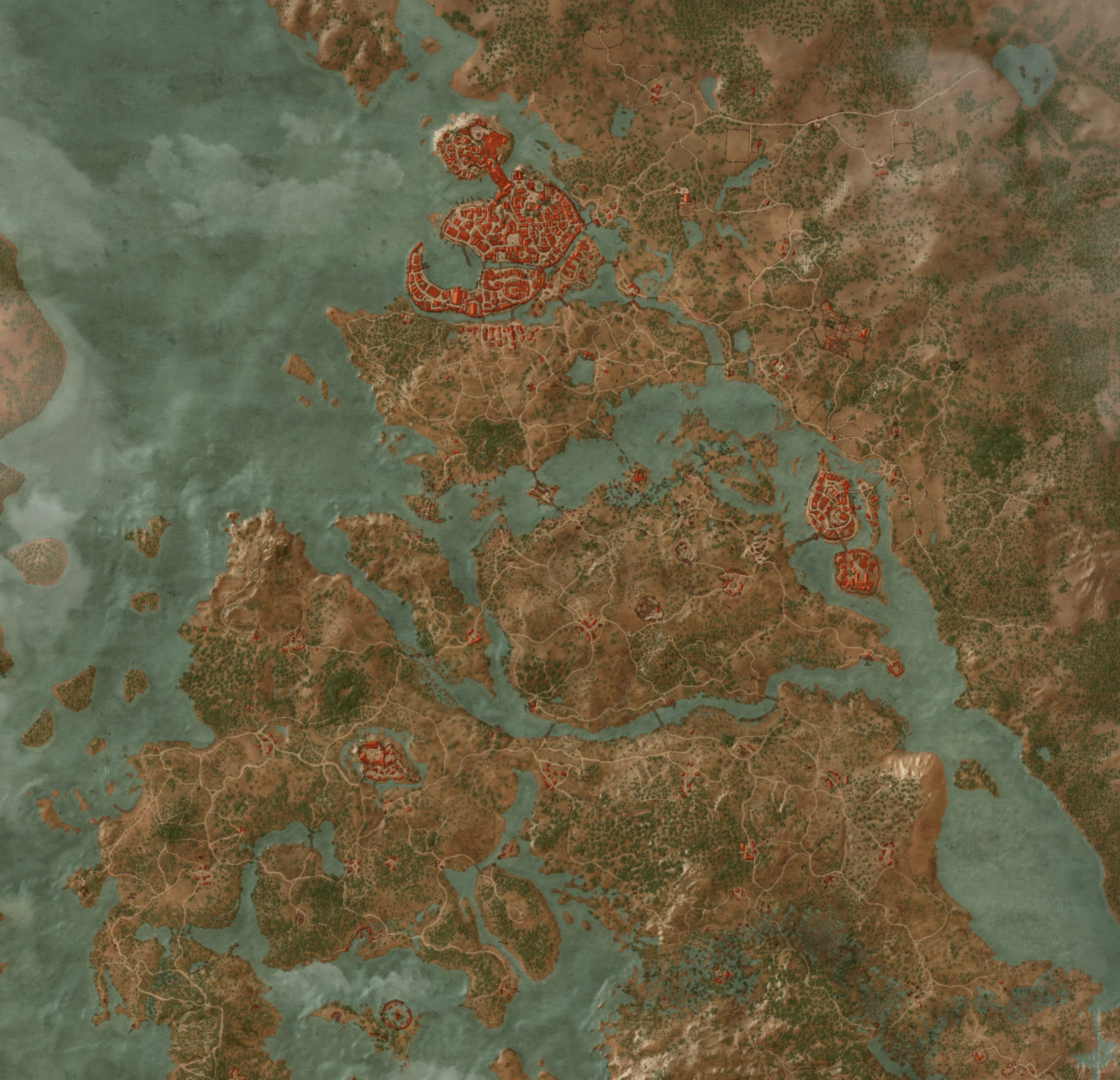 In-game map of the Pontar Region in The Witcher 3 | |
| Beschreibung | |
Art |
Region |
Lage |
Pontar Delta; large mass where the battlefronts between the Nilfgaard and Nördliche Königreiche lie |
In The Witcher 3: Wild Hunt, the Pontar represents part of the world map that covers the Pontar Delta region. It consists of war-torn Velen, the independent city of Novigrad and southern parts of Redanien territory, including the city of Oxenfurt. Although the in-game map labels the two major regions as "Velen & Novigrad", both are contained on the same game world.
The game's rendition of the region excludes some locations from the Witcher saga, namely Eibenbucht, Kranichwerder, the city of Gyscht, and the settlement of Weißbrücke (originally intended to appear).
The region holds (with the Hearts of Stone expansion included):
|
|
|
The region is also a home for 9
Tavernenwirt, 7
Rüstungsschmiede, 12
Kräuterhändler and 69
Velen
The former Temerien province of Velen (also known as No Man's Land) - currently under Nilfgaardian occupation - also constitutes the largest part of the Pontar region. Situated south of Novigrad and west of Oxenfurt, its provisional capital is Krähenfels. The prevailing terrain consists of forests and swamps.
Orte
Keeps and villages
Graufels und Schlammacker
Other locations
Novigrad
Stadtteile
Schnellreisepunkte
Interessante Orte
Eastern outskirts
Grashügel (southern outskirts)
Sturmfelder
East of both Velen and Novigrad's outskirts lie lands and settlements under the jurisdiction of the Kingdom of Redania.
Oxenfurt
Anwesen
Settlements and villages
Other locations
References
| |||||||||||||||||||